


circuit n°6 et 6.1 au retour. col de la valbelle

guariso
User
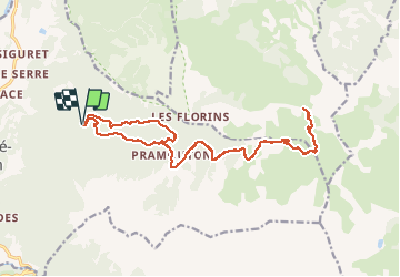

Length
21 km

Max alt
2384 m

Uphill gradient
771 m
Km-Effort
31 km

Min alt
1665 m

Downhill gradient
776 m
Boucle
Yes
Creation date :
2018-09-22 21:35:55.09
Updated on :
2018-09-22 21:35:55.09
2h42
Difficulty : Medium

FREE GPS app for hiking
 SityTrail
IGN / Geographical institutes
SityTrail Plus
The world is yours!
About
Trail Mountain bike of 21 km to be discovered at Provence-Alpes-Côte d'Azur, Hautes-Alpes, Saint-André-d'Embrun. This trail is proposed by guariso.
Description
chemin forestier sans difficulté technique. le retour par la 6.1 est une option pour ceux qui aiment les sensations fortes. sinon revenir par le même chemin !
Photos


Positioning
Country:
France
Region :
Provence-Alpes-Côte d'Azur
Department/Province :
Hautes-Alpes
Municipality :
Saint-André-d'Embrun
Location:
Unknown
Start:(Dec)
Start:(UTM)
307073 ; 4940661 (32T) N.
Comments