


Zevtt - Les Alpilles

kipoura
User
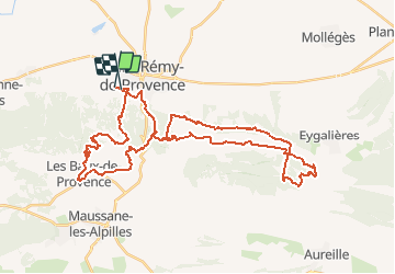

Length
46 km

Max alt
391 m

Uphill gradient
1274 m
Km-Effort
63 km

Min alt
65 m

Downhill gradient
1270 m
Boucle
No
Creation date :
2019-05-03 17:09:41.625
Updated on :
2020-07-29 16:22:35.016
4h06
Difficulty : Difficult

FREE GPS app for hiking
 SityTrail
IGN / Geographical institutes
SityTrail Plus
The world is yours!
About
Trail Mountain bike of 46 km to be discovered at Provence-Alpes-Côte d'Azur, Bouches-du-Rhône, Saint-Rémy-de-Provence. This trail is proposed by kipoura.
Description
- Très beau circuit et très physique ......


Positioning
Country:
France
Region :
Provence-Alpes-Côte d'Azur
Department/Province :
Bouches-du-Rhône
Municipality :
Saint-Rémy-de-Provence
Location:
Unknown
Start:(Dec)
Start:(UTM)
646029 ; 4849361 (31T) N.
Comments