


De Casterino au Lac Vert de Fontanalbe

tracegps
User
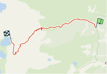

Length
7.2 km

Max alt
2222 m

Uphill gradient
555 m
Km-Effort
12.9 km

Min alt
1723 m

Downhill gradient
62 m
Boucle
No
Creation date :
2014-12-10 00:00:00.0
Updated on :
2014-12-10 00:00:00.0
4h00
Difficulty : Medium

FREE GPS app for hiking
 SityTrail
IGN / Geographical institutes
SityTrail Plus
The world is yours!
About
Trail Walking of 7.2 km to be discovered at Provence-Alpes-Côte d'Azur, Maritime Alps, Tende. This trail is proposed by tracegps.
Description
Rando facile dans le Parc National du Mercantour.
Positioning
Country:
France
Region :
Provence-Alpes-Côte d'Azur
Department/Province :
Maritime Alps
Municipality :
Tende
Location:
Unknown
Start:(Dec)
Start:(UTM)
379616 ; 4885545 (32T) N.
Comments