![](/images/other/stat-length.png)
![Trail Mountain bike Oytier-Saint-Oblas - Boucle autour de Oytier St Oblas - Photo](https://media.geolcdn.com/t/1900/400/ext.pjpeg?maxdim=2&url=https%3A%2F%2Fservices.sitytrail.com%2FGeolivesWS%2FDownloadMedia.ashx%3FTrailID%3D102502%26Media%3D3297_1.jpg)
Boucle autour de Oytier St Oblas
tracegps
User
![Length](/images/other/stat-length.png)
Length
39 km
![Max alt](https://static1.geolcdn.com/siteimages/upload/files/1508320355ic_sort_altitude_max_24dp.png)
Max alt
383 m
![Uphill gradient](https://static1.geolcdn.com/siteimages/upload/files/1508320355ic_sort_den_pos_24dp.png)
Uphill gradient
792 m
![Km-Effort](/images/other/stat-length.png)
Km-Effort
50 km
![Min alt](https://static1.geolcdn.com/siteimages/upload/files/1508320355ic_sort_altitude_min_24dp.png)
Min alt
223 m
![Downhill gradient](https://static1.geolcdn.com/siteimages/upload/files/1508320355ic_sort_den_neg_24dp.png)
Downhill gradient
791 m
![Boucle](https://static1.geolcdn.com/siteimages/upload/files/16400158638029165_repeat_loop_refresh_sync_direction_icon.png)
Boucle
Yes
Creation date :
2014-12-10 00:00:00.0
Updated on :
2014-12-10 00:00:00.0
![Mountain bike](https://static1.geolcdn.com/sitytour/trail-icons/202.png)
2h19
Difficulty : Difficult
![Scan this QR Code to open this trail in the SityTrail application](https://capi.geolives.com/qq0zvz2zws4bq2lad0pu/sitytour/trails/102502/qr.png?size=200)
FREE GPS app for hiking
About
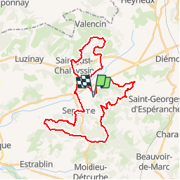
Trail Mountain bike of 39 km to be discovered at Auvergne-Rhône-Alpes, Isère, Oytier-Saint-Oblas. This trail is proposed by tracegps.
Description
Parcours technique autour de Oytier St Oblas (38-Isère) alternant passage de route et chemin, dont une partie empruntée a la rando des collines St Georgoises. A éviter après une forte pluie.
Positioning
Country:
France
Region :
Auvergne-Rhône-Alpes
Department/Province :
Isère
Municipality :
Oytier-Saint-Oblas
Location:
Unknown
Start:(Dec)
Start:(UTM)
657604 ; 5047405 (31T) N.
Comments
Trails nearby
![Trail Walking Saint-Georges-d'Espéranche - rando 20220313 - Photo](https://media.geolcdn.com/t/375/260/ext.jpg?maxdim=2&url=https%3A%2F%2Fmedia.geolcdn.com%2Ff%2F7d0ca670-8fe4-4dee-ac55-4a3d633c9682.jpg)
![Walking Walking](https://static1.geolcdn.com/sitytour/trail-icons/101.png)
rando 20220313
Walking
Easy
Saint-Georges-d'Espéranche,
Auvergne-Rhône-Alpes,
Isère,
France
![](/images/other/stat-length.png)
13.7 km | 17.7 km-effort
3h 44min
![](https://static1.geolcdn.com/siteimages/upload/files/16400158638029165_repeat_loop_refresh_sync_direction_icon.png)
Yes
![Trail Walking Beauvoir-de-Marc - beauvoir - Photo](https://media.geolcdn.com/t/375/260/ext.jpg?maxdim=2&url=https%3A%2F%2Fstatic1.geolcdn.com%2Fsiteimages%2Fupload%2Ffiles%2F1553511878bg_sport_marche.png)
![Walking Walking](https://static1.geolcdn.com/sitytour/trail-icons/101.png)
beauvoir
Walking
Very difficult
Beauvoir-de-Marc,
Auvergne-Rhône-Alpes,
Isère,
France
![](/images/other/stat-length.png)
14.8 km | 20 km-effort
4h 33min
![](https://static1.geolcdn.com/siteimages/upload/files/16400158638029165_repeat_loop_refresh_sync_direction_icon.png)
Yes
![Trail Horseback riding Septème - chteau d'eau Oytier - plaine Moidieu - Photo](https://media.geolcdn.com/t/375/260/ext.jpg?maxdim=2&url=https%3A%2F%2Fstatic1.geolcdn.com%2Fsiteimages%2Fupload%2Ffiles%2F1524743154cheval.jpg)
![Horseback riding Horseback riding](https://static1.geolcdn.com/sitytour/trail-icons/301.png)
chteau d'eau Oytier - plaine Moidieu
Horseback riding
Medium
Septème,
Auvergne-Rhône-Alpes,
Isère,
France
![](/images/other/stat-length.png)
18.9 km | 23 km-effort
2h 35min
![](https://static1.geolcdn.com/siteimages/upload/files/16400158638029165_repeat_loop_refresh_sync_direction_icon.png)
Yes
![Trail Mountain bike Saint-Just-Chaleyssin - Chaponnay JB 27 05 23 - Photo](https://media.geolcdn.com/t/375/260/ext.jpg?maxdim=2&url=https%3A%2F%2Fstatic1.geolcdn.com%2Fsiteimages%2Fupload%2Ffiles%2F1524743154velo.jpg)
![Mountain bike Mountain bike](https://static1.geolcdn.com/sitytour/trail-icons/202.png)
Chaponnay JB 27 05 23
Mountain bike
Medium
Saint-Just-Chaleyssin,
Auvergne-Rhône-Alpes,
Isère,
France
![](/images/other/stat-length.png)
38 km | 49 km-effort
2h 40min
![](https://static1.geolcdn.com/siteimages/upload/files/16400158638029165_repeat_loop_refresh_sync_direction_icon.png)
Yes
![Trail Mountain bike Saint-Just-Chaleyssin - St George JB 36 680 - Photo](https://media.geolcdn.com/t/375/260/ext.jpg?maxdim=2&url=https%3A%2F%2Fstatic1.geolcdn.com%2Fsiteimages%2Fupload%2Ffiles%2F1524743154velo.jpg)
![Mountain bike Mountain bike](https://static1.geolcdn.com/sitytour/trail-icons/202.png)
St George JB 36 680
Mountain bike
Medium
Saint-Just-Chaleyssin,
Auvergne-Rhône-Alpes,
Isère,
France
![](/images/other/stat-length.png)
36 km | 45 km-effort
2h 33min
![](https://static1.geolcdn.com/siteimages/upload/files/16400158638029165_repeat_loop_refresh_sync_direction_icon.png)
Yes
![Trail Horseback riding Oytier-Saint-Oblas - oytier_la combe- péage Septeme - Photo](https://media.geolcdn.com/t/375/260/ext.jpg?maxdim=2&url=https%3A%2F%2Fstatic1.geolcdn.com%2Fsiteimages%2Fupload%2Ffiles%2F1524743154cheval.jpg)
![Horseback riding Horseback riding](https://static1.geolcdn.com/sitytour/trail-icons/301.png)
oytier_la combe- péage Septeme
Horseback riding
Easy
Oytier-Saint-Oblas,
Auvergne-Rhône-Alpes,
Isère,
France
![](/images/other/stat-length.png)
12.4 km | 15.4 km-effort
2h 12min
![](https://static1.geolcdn.com/siteimages/upload/files/16400158638029165_repeat_loop_refresh_sync_direction_icon.png)
Yes
![Trail Mountain bike Saint-Just-Chaleyssin - Septeme long jb 23. 04 - Photo](https://media.geolcdn.com/t/375/260/ext.jpg?maxdim=2&url=https%3A%2F%2Fstatic1.geolcdn.com%2Fsiteimages%2Fupload%2Ffiles%2F1524743154velo.jpg)
![Mountain bike Mountain bike](https://static1.geolcdn.com/sitytour/trail-icons/202.png)
Septeme long jb 23. 04
Mountain bike
Very difficult
Saint-Just-Chaleyssin,
Auvergne-Rhône-Alpes,
Isère,
France
![](/images/other/stat-length.png)
48 km | 61 km-effort
4h 4min
![](https://static1.geolcdn.com/siteimages/upload/files/16400158638029165_repeat_loop_refresh_sync_direction_icon.png)
Yes
![Trail Mountain bike Saint-Just-Chaleyssin - VTT jb 13.04.21 - Photo](https://media.geolcdn.com/t/375/260/ext.jpg?maxdim=2&url=https%3A%2F%2Fstatic1.geolcdn.com%2Fsiteimages%2Fupload%2Ffiles%2F1524743154velo.jpg)
![Mountain bike Mountain bike](https://static1.geolcdn.com/sitytour/trail-icons/202.png)
VTT jb 13.04.21
Mountain bike
Very difficult
Saint-Just-Chaleyssin,
Auvergne-Rhône-Alpes,
Isère,
France
![](/images/other/stat-length.png)
48 km | 60 km-effort
3h 44min
![](https://static1.geolcdn.com/siteimages/upload/files/16400158638029165_repeat_loop_refresh_sync_direction_icon.png)
Yes
![Trail Mountain bike Septème - VTT jb 8.04.21 - Photo](https://media.geolcdn.com/t/375/260/ext.jpg?maxdim=2&url=https%3A%2F%2Fstatic1.geolcdn.com%2Fsiteimages%2Fupload%2Ffiles%2F1524743154velo.jpg)
![Mountain bike Mountain bike](https://static1.geolcdn.com/sitytour/trail-icons/202.png)
VTT jb 8.04.21
Mountain bike
Very difficult
Septème,
Auvergne-Rhône-Alpes,
Isère,
France
![](/images/other/stat-length.png)
48 km | 60 km-effort
3h 32min
![](https://static1.geolcdn.com/siteimages/upload/files/16400158638029165_repeat_loop_refresh_sync_direction_icon.png)
No