


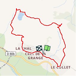
Col de la Chal et Col d'Arves

Isabelle07
User

Length
5 km

Max alt
1858 m

Uphill gradient
300 m
Km-Effort
9 km

Min alt
1553 m

Downhill gradient
303 m
Boucle
Yes
Creation date :
2019-01-15 14:59:39.45
Updated on :
2019-01-15 14:59:39.45
1h32
Difficulty : Medium

FREE GPS app for hiking
 SityTrail
IGN / Geographical institutes
SityTrail Plus
The world is yours!
About
Trail Walking of 5 km to be discovered at Auvergne-Rhône-Alpes, Savoy, Saint-Jean-d'Arves. This trail is proposed by Isabelle07.
Positioning
Country:
France
Region :
Auvergne-Rhône-Alpes
Department/Province :
Savoy
Municipality :
Saint-Jean-d'Arves
Location:
Unknown
Start:(Dec)
Start:(UTM)
285306 ; 5010329 (32T) N.
Comments