


panorama trail

phi14
User
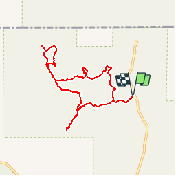

Length
9.9 km

Max alt
1815 m

Uphill gradient
202 m
Km-Effort
12.6 km

Min alt
1757 m

Downhill gradient
202 m
Boucle
Yes
Creation date :
2019-01-15 15:03:38.398
Updated on :
2019-01-15 15:03:38.398
2h42
Difficulty : Easy

FREE GPS app for hiking
 SityTrail
IGN / Geographical institutes
SityTrail Plus
The world is yours!
About
Trail Walking of 9.9 km to be discovered at Utah, Kane County. This trail is proposed by phi14.
Positioning
Country:
United States
Region :
Utah
Department/Province :
Kane County
Municipality :
Kodachrome Basin Campground
Location:
Unknown
Start:(Dec)
Start:(UTM)
412346 ; 4153311 (12S) N.
Comments