


sortie2308

jpfrobert
User
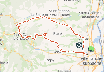

Length
39 km

Max alt
664 m

Uphill gradient
734 m
Km-Effort
49 km

Min alt
176 m

Downhill gradient
733 m
Boucle
No
Creation date :
2019-01-15 15:06:08.671
Updated on :
2019-01-15 15:06:08.671
3h00
Difficulty : Unknown

FREE GPS app for hiking
 SityTrail
IGN / Geographical institutes
SityTrail Plus
The world is yours!
About
Trail Other activity of 39 km to be discovered at Auvergne-Rhône-Alpes, Rhône, Villefranche-sur-Saône. This trail is proposed by jpfrobert.
Positioning
Country:
France
Region :
Auvergne-Rhône-Alpes
Department/Province :
Rhône
Municipality :
Villefranche-sur-Saône
Location:
Unknown
Start:(Dec)
Start:(UTM)
632817 ; 5095036 (31T) N.
Comments