


chambord

stef789
User GUIDE
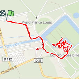

Length
3.4 km

Max alt
89 m

Uphill gradient
33 m
Km-Effort
3.8 km

Min alt
75 m

Downhill gradient
33 m
Boucle
Yes
Creation date :
2019-01-15 15:10:45.906
Updated on :
2019-01-15 15:10:45.906
2h43
Difficulty : Unknown

FREE GPS app for hiking
 SityTrail
IGN / Geographical institutes
SityTrail Plus
The world is yours!
About
Trail Walking of 3.4 km to be discovered at Centre-Loire Valley, Loir-et-Cher, Chambord. This trail is proposed by stef789.
Positioning
Country:
France
Region :
Centre-Loire Valley
Department/Province :
Loir-et-Cher
Municipality :
Chambord
Location:
Unknown
Start:(Dec)
Start:(UTM)
387983 ; 5274993 (31T) N.
Comments