


lafage aude 25-8-18

labarone
User
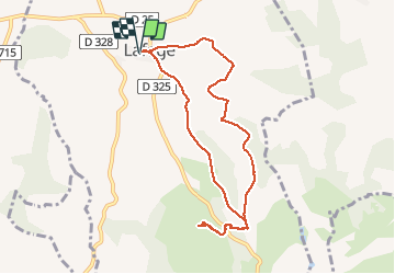

Length
9 km

Max alt
386 m

Uphill gradient
231 m
Km-Effort
12.1 km

Min alt
286 m

Downhill gradient
230 m
Boucle
Yes
Creation date :
2019-01-15 15:12:23.446
Updated on :
2019-01-15 15:12:23.446
2h26
Difficulty : Very easy

FREE GPS app for hiking
 SityTrail
IGN / Geographical institutes
SityTrail Plus
The world is yours!
About
Trail Walking of 9 km to be discovered at Occitania, Aude, Lafage. This trail is proposed by labarone.
Description
Le jour de la fête Rando tranquille beaux tournesols
Photos


Positioning
Country:
France
Region :
Occitania
Department/Province :
Aude
Municipality :
Lafage
Location:
Unknown
Start:(Dec)
Start:(UTM)
407537 ; 4780760 (31T) N.
Comments