


Sentier des clochers(Técou)

CANON2
User
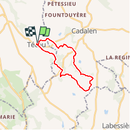

Length
10.8 km

Max alt
324 m

Uphill gradient
237 m
Km-Effort
14 km

Min alt
208 m

Downhill gradient
237 m
Boucle
Yes
Creation date :
2019-05-15 13:07:36.949
Updated on :
2019-05-15 13:07:37.26
2h40
Difficulty : Easy

FREE GPS app for hiking
 SityTrail
IGN / Geographical institutes
SityTrail Plus
The world is yours!
About
Trail Walking of 10.8 km to be discovered at Occitania, Tarn, Técou. This trail is proposed by CANON2.
Positioning
Country:
France
Region :
Occitania
Department/Province :
Tarn
Municipality :
Técou
Location:
Unknown
Start:(Dec)
Start:(UTM)
415598 ; 4855063 (31T) N.
Comments