


Boucle autour de St Vaast en C

BrassensJC
User
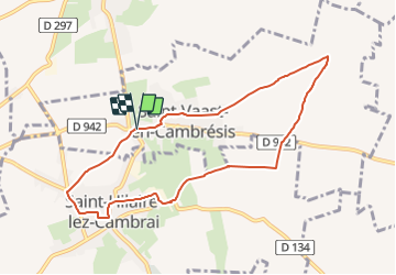

Length
7.9 km

Max alt
102 m

Uphill gradient
72 m
Km-Effort
8.8 km

Min alt
69 m

Downhill gradient
72 m
Boucle
Yes
Creation date :
2019-01-15 15:32:08.129
Updated on :
2019-01-15 15:32:08.129
1h57
Difficulty : Easy

FREE GPS app for hiking
 SityTrail
IGN / Geographical institutes
SityTrail Plus
The world is yours!
About
Trail Walking of 7.9 km to be discovered at Hauts-de-France, Nord, Saint-Vaast-en-Cambrésis. This trail is proposed by BrassensJC.
Positioning
Country:
France
Region :
Hauts-de-France
Department/Province :
Nord
Municipality :
Saint-Vaast-en-Cambrésis
Location:
Unknown
Start:(Dec)
Start:(UTM)
529832 ; 5560032 (31U) N.
Comments