Sur le Mont Alta

tracegps
User
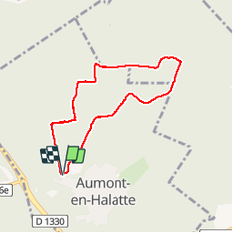

Length
6.1 km

Max alt
152 m

Uphill gradient
77 m
Km-Effort
7.1 km

Min alt
105 m

Downhill gradient
78 m
Boucle
Yes
Creation date :
2014-12-10 00:00:00.0
Updated on :
2014-12-10 00:00:00.0
1h30
Difficulty : Medium

FREE GPS app for hiking
 SityTrail
IGN / Geographical institutes
SityTrail Plus
The world is yours!
About
Trail Walking of 6.1 km to be discovered at Hauts-de-France, Oise, Aumont-en-Halatte. This trail is proposed by tracegps.
Description
Circuit proposé par le Parc Naturel Régional Oise-Pays de France. Fiche disponible ICI Trace GPS enregistrée le 14/07/2009 sur Evadeo Primo
Positioning
Country:
France
Region :
Hauts-de-France
Department/Province :
Oise
Municipality :
Aumont-en-Halatte
Location:
Unknown
Start:(Dec)
Start:(UTM)
466986 ; 5453267 (31U) N.
Comments