


ableiges boissy voie Jules César

Glurps
User

Length
13.7 km

Max alt
114 m

Uphill gradient
250 m
Km-Effort
17.1 km

Min alt
40 m

Downhill gradient
250 m
Boucle
Yes
Creation date :
2019-01-15 15:58:54.067
Updated on :
2019-01-15 15:58:54.067
3h04
Difficulty : Very easy

FREE GPS app for hiking
 SityTrail
IGN / Geographical institutes
SityTrail Plus
The world is yours!
About
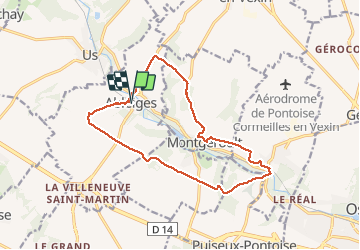
Trail Walking of 13.7 km to be discovered at Ile-de-France, Val-d'Oise, Ableiges. This trail is proposed by Glurps.
Positioning
Country:
France
Region :
Ile-de-France
Department/Province :
Val-d'Oise
Municipality :
Ableiges
Location:
Unknown
Start:(Dec)
Start:(UTM)
425632 ; 5437929 (31U) N.
Comments