Trail Mountain bike Barbery - VTT autour de Barbery - Photo

VTT autour de Barbery

 tracegps
tracegps

User

© OpenStreetMap contributors
Length
Length
40 km
Max alt
Max alt
290 m
Uphill gradient
Uphill gradient
528 m
Km-Effort
Km-Effort  
47 km
Min alt
Min alt
131 m
Downhill gradient
Downhill gradient
528 m
Boucle
Boucle
Yes
Creation date :
2014-12-10 00:00:00.0
Updated on :
2014-12-10 00:00:00.0

(0 Reviews)

Mountain bike
Mountain bike
2h30
Difficulty : Medium

Scan this QR Code to open this trail in the SityTrail application

FREE GPS app for hiking

Logo SityTrail SityTrail

IGN / Geographical institutes

Download SityTrail from the App Store Download SityTrail from Google Play

Logo SityTrail SityTrail World

The world is yours!

Download SityTrail from the App Store Download SityTrail from Google Play Download SityTrail on Huawei AppGallery

About

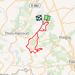
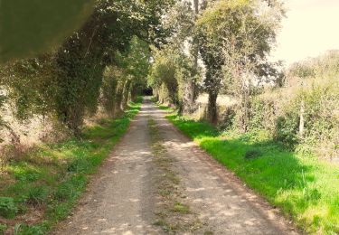
Trail Mountain bike of 40 km to be discovered at Normandy, Calvados, Barbery. This trail is proposed by tracegps.

Description

Départ de la mairie de Barbery. Le circuit est relativement facile avec des chemins très roulants. Certains passages sont assez techniques: ornières, pierriers... Bonne promenade.

Elevation profile

Photos

Positioning

Country:
France
Region :
Normandy
Department/Province :
Calvados
Municipality :
Barbery
Location:
Unknown
Start:(UTM)
693745 ; 5431979 (30U) N.

Trails nearby

Trail Geocaching Barbery - GC745R5 = https://coord.info/GC745R5 - Photo
Geocaching
yannick-p

Geocaching

Easy
Barbery, Normandy, Calvados, France
6.5 km | 7.5 km-effort
2h 40min
Yes
Trail Walking Barbery - Babery Annick - Photo
Walking
gr1346

Walking

Medium
Barbery, Normandy, Calvados, France
9 km | 10.1 km-effort
2h 34min
Yes
Trail On foot Bretteville-sur-Laize - Bretteville sur Laize / Urville - Photo
On foot
Privatb

On foot

Easy
(1)
Bretteville-sur-Laize, Normandy, Calvados, France
15.3 km | 18 km-effort
4h 5min
Yes
Trail Walking Boulon - rando - Photo
Walking
NICOLAS.Monique

Walking

Very easy
Boulon, Normandy, Calvados, France
33 km | 37 km-effort
14min
No
Trail Walking Boulon - boulon-99 - Photo
Walking
gr1346

Walking

Very easy
Boulon, Normandy, Calvados, France
7.6 km | 8.9 km-effort
2h 20min
No
Trail Walking Gouvix - Gouvix - Photo
Walking
Jeff_314

Walking

Easy
Gouvix, Normandy, Calvados, France
5.7 km | 6.3 km-effort
1h 50min
Yes
Trail Walking Urville - Urville et La Laize - Photo
Walking
Jeff_314

Walking

Medium
Urville, Normandy, Calvados, France
5.1 km | 6.2 km-effort
1h 43min
Yes
Trail Mountain bike Cintheaux - Pays du Cinglais - Photo
Mountain bike
tracegps

Mountain bike

Medium
Cintheaux, Normandy, Calvados, France
38 km | 43 km-effort
2h 15min
Yes
Trail Walking Urville - campeaux  repérage  - Photo
Walking
chrisdouville

Walking

Very difficult
Urville, Normandy, Calvados, France
110 km | 131 km-effort
63h 58min
No


Close
My subscriptions