


st just stleo

pjoly
User
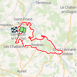

Length
38 km

Max alt
397 m

Uphill gradient
845 m
Km-Effort
49 km

Min alt
236 m

Downhill gradient
844 m
Boucle
Yes
Creation date :
2019-03-27 15:41:09.002
Updated on :
2019-03-27 15:41:09.065
4h40
Difficulty : Unknown

FREE GPS app for hiking
 SityTrail
IGN / Geographical institutes
SityTrail Plus
The world is yours!
About
Trail Other activity of 38 km to be discovered at New Aquitaine, Haute-Vienne, Saint-Just-le-Martel. This trail is proposed by pjoly.
Positioning
Country:
France
Region :
New Aquitaine
Department/Province :
Haute-Vienne
Municipality :
Saint-Just-le-Martel
Location:
Unknown
Start:(Dec)
Start:(UTM)
374774 ; 5079948 (31T) N.
Comments