


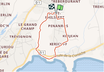
St Philibert

toporient
User

Length
3 km

Max alt
23 m

Uphill gradient
21 m
Km-Effort
3.3 km

Min alt
3 m

Downhill gradient
22 m
Boucle
Yes
Creation date :
2019-01-15 16:09:41.574
Updated on :
2019-01-15 16:09:41.574
43m
Difficulty : Very easy

FREE GPS app for hiking
 SityTrail
IGN / Geographical institutes
SityTrail Plus
The world is yours!
About
Trail Walking of 3 km to be discovered at Brittany, Finistère, Trégunc. This trail is proposed by toporient.
Description
Circuit en boucle à partir de l'église de St Philibert. L'itinéraire rejoint le sentier côtier entre les plages du Don et de Trez Cao puis revient par le chemin du parcours sportif.
Positioning
Country:
France
Region :
Brittany
Department/Province :
Finistère
Municipality :
Trégunc
Location:
Unknown
Start:(Dec)
Start:(UTM)
437673 ; 5295026 (30T) N.
Comments