


Tour du Pech de Bugarach depuis Bugarach

maupassant38
User
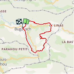

Length
13.8 km

Max alt
1209 m

Uphill gradient
828 m
Km-Effort
25 km

Min alt
461 m

Downhill gradient
817 m
Boucle
Yes
Creation date :
2019-02-22 22:30:28.452
Updated on :
2019-02-22 22:30:28.472
4h29
Difficulty : Difficult

FREE GPS app for hiking
 SityTrail
IGN / Geographical institutes
SityTrail Plus
The world is yours!
About
Trail Walking of 13.8 km to be discovered at Occitania, Aude, Bugarach. This trail is proposed by maupassant38.
Positioning
Country:
France
Region :
Occitania
Department/Province :
Aude
Municipality :
Bugarach
Location:
Unknown
Start:(Dec)
Start:(UTM)
446923 ; 4747286 (31T) N.
Comments