


20180913-Belbeuf

doudet
User
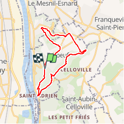

Length
12.5 km

Max alt
156 m

Uphill gradient
301 m
Km-Effort
16.5 km

Min alt
8 m

Downhill gradient
301 m
Boucle
Yes
Creation date :
2019-01-15 16:12:30.998
Updated on :
2019-01-15 16:12:30.998
3h27
Difficulty : Medium

FREE GPS app for hiking
 SityTrail
IGN / Geographical institutes
SityTrail Plus
The world is yours!
About
Trail Walking of 12.5 km to be discovered at Normandy, Seine-Maritime, Belbeuf. This trail is proposed by doudet.
Description
Boucle A-R au départ de l'Allée des chataigniers à Belbeuf
Positioning
Country:
France
Region :
Normandy
Department/Province :
Seine-Maritime
Municipality :
Belbeuf
Location:
Unknown
Start:(Dec)
Start:(UTM)
364565 ; 5471535 (31U) N.
Comments