


GR 16 Florenville Sainte Cécile

ramagufa
User
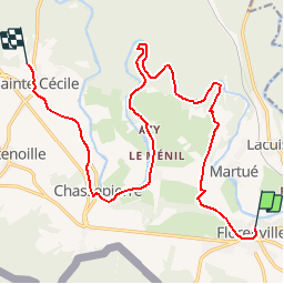

Length
17.1 km

Max alt
368 m

Uphill gradient
236 m
Km-Effort
20 km

Min alt
277 m

Downhill gradient
270 m
Boucle
No
Creation date :
2019-04-16 19:16:30.556
Updated on :
2019-04-16 19:16:30.594
4h25
Difficulty : Easy

FREE GPS app for hiking
 SityTrail
IGN / Geographical institutes
SityTrail Plus
The world is yours!
About
Trail Walking of 17.1 km to be discovered at Wallonia, Luxembourg, Florenville. This trail is proposed by ramagufa.
Positioning
Country:
Belgium
Region :
Wallonia
Department/Province :
Luxembourg
Municipality :
Florenville
Location:
Florenville
Start:(Dec)
Start:(UTM)
666669 ; 5507905 (31U) N.
Comments