Trail Walking Châteaubleau - Boucle gallo-romaine - Châteaubleau - Photo

Boucle gallo-romaine - Châteaubleau

 tracegps
tracegps

User

© OpenStreetMap contributors
Length
Length
17.2 km
Max alt
Max alt
156 m
Uphill gradient
Uphill gradient
126 m
Km-Effort
Km-Effort  
18.9 km
Min alt
Min alt
125 m
Downhill gradient
Downhill gradient
126 m
Boucle
Boucle
Yes
Creation date :
2014-12-10 00:00:00.0
Updated on :
2014-12-10 00:00:00.0

(0 Reviews)

Walking
Walking
4h19
Difficulty : Very difficult

Scan this QR Code to open this trail in the SityTrail application

FREE GPS app for hiking

Logo SityTrail SityTrail

IGN / Geographical institutes

Download SityTrail from the App Store Download SityTrail from Google Play

Logo SityTrail SityTrail World

The world is yours!

Download SityTrail from the App Store Download SityTrail from Google Play Download SityTrail on Huawei AppGallery

About

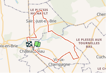
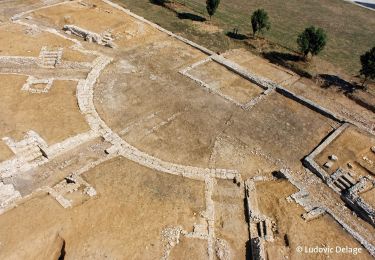
Trail Walking of 17.2 km to be discovered at Ile-de-France, Seine-et-Marne, Châteaubleau. This trail is proposed by tracegps.

Description

Circuit proposé par la Communauté de Communes de la Brie Nangissienne. Départ de la mairie de Châteaubleau, de Vieux-Champagne ou de Saint-Just-en-Brie. Retrouvez le circuit et son descriptif sur le site de la Communauté de Communes de la Brie Nangissienne . Ce circuit a été numérisé par les randonneurs du CODEPEM. Merci à Jean-Marie.

Elevation profile

Photos

Positioning

Country:
France
Region :
Ile-de-France
Department/Province :
Seine-et-Marne
Municipality :
Châteaubleau
Location:
Unknown
Start:(UTM)
507995 ; 5381665 (31U) N.

Trails nearby

Trail Walking Châteaubleau - Boucle gallo-romaine de Châteaubleau - Photo
Walking
pikibangi

Walking

Very difficult
Châteaubleau, Ile-de-France, Seine-et-Marne, France
17.5 km | 19.2 km-effort
4h 21min
Yes
Trail Walking Vieux-Champagne - Ruine gallo romaine - Châteaubleau - Photo
Walking
tracegps

Walking

Difficult
Vieux-Champagne, Ile-de-France, Seine-et-Marne, France
17.8 km | 19.5 km-effort
4h 30min
Yes
Trail Other activity Rampillon - RAMPILLON - Photo
Other activity
bellicaud

Other activity

Easy
Rampillon, Ile-de-France, Seine-et-Marne, France
18.7 km | 20 km-effort
4h 37min
Yes
Trail On foot Rampillon - Sur les traces des templiers  - Photo
On foot
francoisep

On foot

Easy
Rampillon, Ile-de-France, Seine-et-Marne, France
16.6 km | 17.6 km-effort
4h 0min
Yes
Trail Walking Rampillon - Rampillon - Photo
Walking

Walking

Difficult
Rampillon, Ile-de-France, Seine-et-Marne, France
16.6 km | 17.7 km-effort
4h 1min
Yes
Trail Walking Vieux-Champagne - Vieux-Champagne - Photo
Walking
francoisep

Walking

Easy
Vieux-Champagne, Ile-de-France, Seine-et-Marne, France
16.8 km | 18.4 km-effort
4h 5min
Yes
Trail Walking Châteaubleau - Brie Nangissienne - Photo
Walking
francoisep

Walking

Very difficult
Châteaubleau, Ile-de-France, Seine-et-Marne, France
18.2 km | 19.9 km-effort
4h 25min
Yes
Trail On foot Rampillon - Rampillon sur les traces des templiers - Photo
On foot
bernard77

On foot

Easy
Rampillon, Ile-de-France, Seine-et-Marne, France
11.3 km | 12.1 km-effort
2h 45min
Yes
Trail Walking Châteaubleau - Châteaubleau - Photo
Walking
Tournan

Walking

Very difficult
Châteaubleau, Ile-de-France, Seine-et-Marne, France
17.5 km | 19.2 km-effort
4h 21min
Yes


Close
My subscriptions