


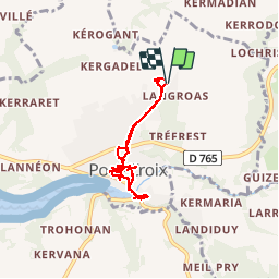
Visite de Pont-Croix

rigol05
User

Length
6.1 km

Max alt
71 m

Uphill gradient
92 m
Km-Effort
7.3 km

Min alt
1 m

Downhill gradient
91 m
Boucle
Yes
Creation date :
2018-10-04 20:28:12.582
Updated on :
2018-10-04 20:28:12.582
1h35
Difficulty : Easy

FREE GPS app for hiking
 SityTrail
IGN / Geographical institutes
SityTrail Plus
The world is yours!
About
Trail Walking of 6.1 km to be discovered at Brittany, Finistère, Pont-Croix. This trail is proposed by rigol05.
Description
sortie du 19/09/2018 au départ du camping.
Pont-Croix est une cité de caractère riche en patrimoine historique
Positioning
Country:
France
Region :
Brittany
Department/Province :
Finistère
Municipality :
Pont-Croix
Location:
Unknown
Start:(Dec)
Start:(UTM)
389590 ; 5322933 (30U) N.
Comments