


Resteigne 20'09'2018

fra_depoorter
User
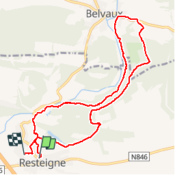

Length
9.4 km

Max alt
279 m

Uphill gradient
205 m
Km-Effort
12.1 km

Min alt
170 m

Downhill gradient
206 m
Boucle
No
Creation date :
2019-01-15 16:37:10.712
Updated on :
2019-01-15 16:37:10.712
2h13
Difficulty : Unknown

FREE GPS app for hiking
 SityTrail
IGN / Geographical institutes
SityTrail Plus
The world is yours!
About
Trail Walking of 9.4 km to be discovered at Wallonia, Luxembourg, Tellin. This trail is proposed by fra_depoorter.
Positioning
Country:
Belgium
Region :
Wallonia
Department/Province :
Luxembourg
Municipality :
Tellin
Location:
Resteigne
Start:(Dec)
Start:(UTM)
655750 ; 5550190 (31U) N.
Comments