Trail Mountain bike Anost - Espace VTT FFC Parc du Morvan - Circuit n°5 - Anost - Photo

Espace VTT FFC Parc du Morvan - Circuit n°5 - Anost

 tracegps
tracegps

User

© OpenStreetMap contributors
Length
Length
37 km
Max alt
Max alt
766 m
Uphill gradient
Uphill gradient
1084 m
Km-Effort
Km-Effort  
51 km
Min alt
Min alt
371 m
Downhill gradient
Downhill gradient
1085 m
Boucle
Boucle
Yes
Creation date :
2014-12-10 00:00:00.0
Updated on :
2014-12-10 00:00:00.0

(0 Reviews)

Mountain bike
Mountain bike
3h30
Difficulty : Very difficult

Scan this QR Code to open this trail in the SityTrail application

FREE GPS app for hiking

Logo SityTrail SityTrail

IGN / Geographical institutes

Download SityTrail from the App Store Download SityTrail from Google Play

Logo SityTrail SityTrail World

The world is yours!

Download SityTrail from the App Store Download SityTrail from Google Play Download SityTrail on Huawei AppGallery

About

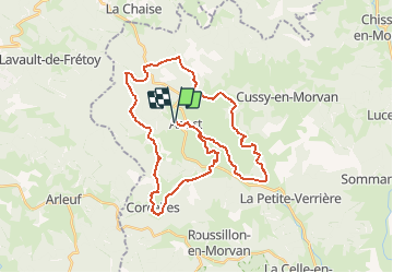
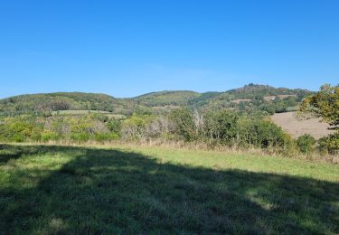
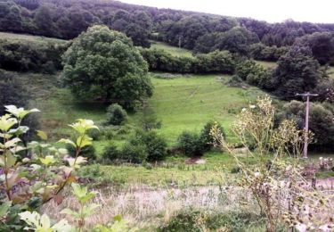
Trail Mountain bike of 37 km to be discovered at Bourgogne-Franche-Comté, Saône-et-Loire, Anost. This trail is proposed by tracegps.

Description

Espace VTT FFC du Parc du Morvan - Circuit n°5 – Anost. Circuit labellisé par la Fédération Française de Cyclisme. Points infos : Office du Tourisme de la Maison du Parc - 58230 Saint Brisson : 03 86 78 79 57 - Email : contact at parcdumorvan.org Office du Tourisme d'Autun
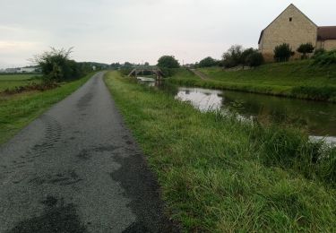
Elevation profile

Photos

Positioning

Country:
France
Region :
Bourgogne-Franche-Comté
Department/Province :
Saône-et-Loire
Municipality :
Anost
Location:
Unknown
Start:(UTM)
582897 ; 5214400 (31T) N.

Trails nearby

Trail Walking Planchez - Trek Morvan 2020 : Journée 4/5 - De L'huis prunelle a Alligny en Morvan - Photo
Walking
GUIDE
chessyca

Walking

Medium
Planchez, Bourgogne-Franche-Comté, Nièvre, France
31 km | 38 km-effort
8h 10min
No
Trail On foot Anost - Voie du Tacot - Photo
On foot
GUIDE+

On foot

Easy
Anost, Bourgogne-Franche-Comté, Saône-et-Loire, France
7.9 km | 11.6 km-effort
2h 37min
No
Trail Walking Anost - Anost Circuit des Galvachers - Photo
Walking
meunier.ph.

Walking

Easy
Anost, Bourgogne-Franche-Comté, Saône-et-Loire, France
12.7 km | 17.2 km-effort
2h 45min
Yes
Trail On foot Anost - La Bouche des Gaudry - Photo
On foot
GUIDE+

On foot

Easy
Anost, Bourgogne-Franche-Comté, Saône-et-Loire, France
7.5 km | 11.2 km-effort
2h 32min
No
Trail Road bike Anost - Anost - Decize - Photo
Road bike
berhin

Road bike

Very difficult
Anost, Bourgogne-Franche-Comté, Saône-et-Loire, France
81 km | 95 km-effort
12h 48min
No
Trail Walking Lavault-de-Frétoy - Enclos à sangliers - La Grange Vermoy - Photo
Walking
tracegps

Walking

Medium
Lavault-de-Frétoy, Bourgogne-Franche-Comté, Nièvre, France
6.9 km | 9.1 km-effort
1h 30min
Yes
Trail Mountain bike Anost - Espace VTT FFC Parc du Morvan - Circuit n°4 - Anost - Photo
Mountain bike
tracegps

Mountain bike

Difficult
(1)
Anost, Bourgogne-Franche-Comté, Saône-et-Loire, France
14.3 km | 19.8 km-effort
1h 15min
Yes
Trail Mountain bike Anost - Espace VTT FFC Parc du Morvan - Circuit n°2 - Anost - Photo
Mountain bike
tracegps

Mountain bike

Difficult
Anost, Bourgogne-Franche-Comté, Saône-et-Loire, France
11.4 km | 15.3 km-effort
1h 0min
Yes
Trail Mountain bike Anost - Espace VTT FFC Parc du Morvan - Circuit n°1 - Anost - Photo
Mountain bike
tracegps

Mountain bike

Difficult
(1)
Anost, Bourgogne-Franche-Comté, Saône-et-Loire, France
7.7 km | 10.9 km-effort
40min
Yes


Close
My subscriptions