


Calanques Cassis

acatala
User
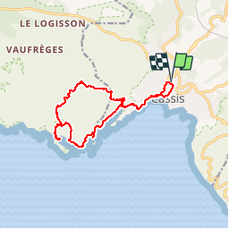

Length
15 km

Max alt
192 m

Uphill gradient
541 m
Km-Effort
22 km

Min alt
5 m

Downhill gradient
539 m
Boucle
Yes
Creation date :
2019-01-15 16:42:21.307
Updated on :
2019-01-15 16:42:21.307
5h40
Difficulty : Medium

FREE GPS app for hiking
 SityTrail
IGN / Geographical institutes
SityTrail Plus
The world is yours!
About
Trail Walking of 15 km to be discovered at Provence-Alpes-Côte d'Azur, Bouches-du-Rhône, Cassis. This trail is proposed by acatala.
Description
calanques d en Vau et Porpin
Positioning
Country:
France
Region :
Provence-Alpes-Côte d'Azur
Department/Province :
Bouches-du-Rhône
Municipality :
Cassis
Location:
Unknown
Start:(Dec)
Start:(UTM)
706362 ; 4788221 (31T) N.
Comments