


auxerre cravant

bruno38
User
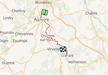

Length
24 km

Max alt
282 m

Uphill gradient
440 m
Km-Effort
30 km

Min alt
94 m

Downhill gradient
449 m
Boucle
No
Creation date :
2019-01-15 16:42:29.631
Updated on :
2019-01-15 16:42:29.631
7m
Difficulty : Unknown

FREE GPS app for hiking
 SityTrail
IGN / Geographical institutes
SityTrail Plus
The world is yours!
About
Trail Other activity of 24 km to be discovered at Bourgogne-Franche-Comté, Yonne, Auxerre. This trail is proposed by bruno38.
Description
1er jour de auxerre vézelay
Positioning
Country:
France
Region :
Bourgogne-Franche-Comté
Department/Province :
Yonne
Municipality :
Auxerre
Location:
Unknown
Start:(Dec)
Start:(UTM)
542530 ; 5293767 (31T) N.
Comments