


randoluech

jpfrobert
User
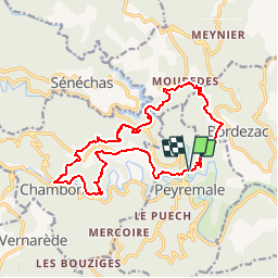

Length
17.3 km

Max alt
508 m

Uphill gradient
824 m
Km-Effort
28 km

Min alt
195 m

Downhill gradient
825 m
Boucle
Yes
Creation date :
2019-01-15 16:53:14.962
Updated on :
2019-01-15 16:53:14.962
--
Difficulty : Easy

FREE GPS app for hiking
 SityTrail
IGN / Geographical institutes
SityTrail Plus
The world is yours!
About
Trail Walking of 17.3 km to be discovered at Occitania, Gard, Peyremale. This trail is proposed by jpfrobert.
Positioning
Country:
France
Region :
Occitania
Department/Province :
Gard
Municipality :
Peyremale
Location:
Unknown
Start:(Dec)
Start:(UTM)
584667 ; 4906275 (31T) N.
Comments