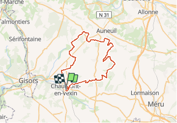
De Chaumont en Vexin au bois de Vilotran

tracegps
User


2h30
Difficulty : Medium

FREE GPS app for hiking
 SityTrail
IGN / Geographical institutes
SityTrail Plus
The world is yours!
About
Trail Mountain bike of 53 km to be discovered at Hauts-de-France, Oise, Chaumont-en-Vexin. This trail is proposed by tracegps.
Description
Le 55km organisé par Chaumont le 08/06/2008. Départ de Chaumont en direction de la Houssoye pour rejoindre le bois de Vilotran et retour via Fresneaux-Montchevreuil. Parcours roulant sans grandes difficultés.
Positioning
Comments