


Val en Vienne Tigy et l'orée de la Sologne

BRASSENS
User
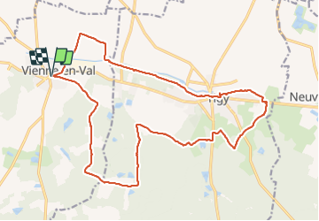

Length
21 km

Max alt
150 m

Uphill gradient
169 m
Km-Effort
24 km

Min alt
100 m

Downhill gradient
169 m
Boucle
Yes
Creation date :
2019-01-15 16:56:19.305
Updated on :
2019-01-15 16:56:19.305
4h15
Difficulty : Medium

FREE GPS app for hiking
 SityTrail
IGN / Geographical institutes
SityTrail Plus
The world is yours!
About
Trail Walking of 21 km to be discovered at Centre-Loire Valley, Loiret, Vienne-en-Val. This trail is proposed by BRASSENS.
Positioning
Country:
France
Region :
Centre-Loire Valley
Department/Province :
Loiret
Municipality :
Vienne-en-Val
Location:
Unknown
Start:(Dec)
Start:(UTM)
435322 ; 5294522 (31T) N.
Comments