


le champ massot

gsouque
User
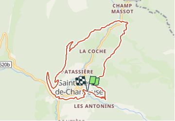

Length
10.2 km

Max alt
1208 m

Uphill gradient
586 m
Km-Effort
18 km

Min alt
797 m

Downhill gradient
582 m
Boucle
Yes
Creation date :
2019-01-15 16:57:56.708
Updated on :
2019-01-15 16:57:56.708
3h38
Difficulty : Unknown

FREE GPS app for hiking
 SityTrail
IGN / Geographical institutes
SityTrail Plus
The world is yours!
About
Trail Walking of 10.2 km to be discovered at Auvergne-Rhône-Alpes, Isère, Saint-Pierre-de-Chartreuse. This trail is proposed by gsouque.
Positioning
Country:
France
Region :
Auvergne-Rhône-Alpes
Department/Province :
Isère
Municipality :
Saint-Pierre-de-Chartreuse
Location:
Unknown
Start:(Dec)
Start:(UTM)
720750 ; 5024716 (31T) N.
Comments