


Le Gros Calan

Bredu
User

Length
8.7 km

Max alt
303 m

Uphill gradient
185 m
Km-Effort
11.2 km

Min alt
149 m

Downhill gradient
188 m
Boucle
Yes
Creation date :
2019-01-15 17:08:27.754
Updated on :
2019-01-15 17:08:27.754
2h35
Difficulty : Easy

FREE GPS app for hiking
 SityTrail
IGN / Geographical institutes
SityTrail Plus
The world is yours!
About
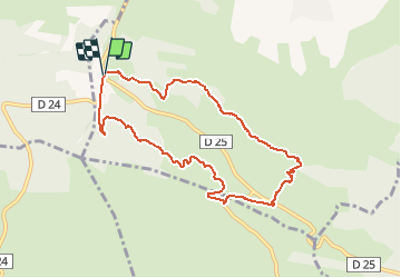
Trail Walking of 8.7 km to be discovered at Provence-Alpes-Côte d'Azur, Bouches-du-Rhône, Eygalières. This trail is proposed by Bredu.
Description
Départ : carrefour D24/D25 - suivre le Chemin forestier du Gros Calan - revenir par la Chemin du Mas de Pascal.
Positioning
Country:
France
Region :
Provence-Alpes-Côte d'Azur
Department/Province :
Bouches-du-Rhône
Municipality :
Eygalières
Location:
Unknown
Start:(Dec)
Start:(UTM)
654685 ; 4845558 (31T) N.
Comments