


arsel 2-10-18 cabrières 34

labarone
User
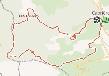

Length
16.5 km

Max alt
364 m

Uphill gradient
598 m
Km-Effort
24 km

Min alt
102 m

Downhill gradient
601 m
Boucle
Yes
Creation date :
2019-01-15 17:08:31.108
Updated on :
2019-01-15 17:08:31.108
4h56
Difficulty : Difficult

FREE GPS app for hiking
 SityTrail
IGN / Geographical institutes
SityTrail Plus
The world is yours!
About
Trail Walking of 16.5 km to be discovered at Occitania, Hérault, Cabrières. This trail is proposed by labarone.
Description
Belle randonnée dernière descente un peu difficile
Positioning
Country:
France
Region :
Occitania
Department/Province :
Hérault
Municipality :
Cabrières
Location:
Unknown
Start:(Dec)
Start:(UTM)
529361 ; 4824467 (31T) N.
Comments