


telethon 2018

association
User

Length
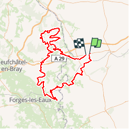
141 km

Max alt
245 m

Uphill gradient
1606 m
Km-Effort
162 km

Min alt
96 m

Downhill gradient
1601 m
Boucle
No
Creation date :
2019-01-15 17:19:32.518
Updated on :
2019-01-15 17:19:32.518
6h00
Difficulty : Unknown

FREE GPS app for hiking
 SityTrail
IGN / Geographical institutes
SityTrail Plus
The world is yours!
About
Trail Other activity of 141 km to be discovered at Hauts-de-France, Somme, Lignières-Châtelain. This trail is proposed by association.
Positioning
Country:
France
Region :
Hauts-de-France
Department/Province :
Somme
Municipality :
Lignières-Châtelain
Location:
Unknown
Start:(Dec)
Start:(UTM)
418437 ; 5514202 (31U) N.
Comments