


W 2018 / 07/ 10 Montcenis la Tour du Bost

clabidault
User
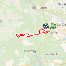

Length
17.8 km

Max alt
544 m

Uphill gradient
478 m
Km-Effort
24 km

Min alt
350 m

Downhill gradient
482 m
Boucle
Yes
Creation date :
2019-01-15 17:24:11.173
Updated on :
2019-01-29 10:34:01.215
5h07
Difficulty : Medium

FREE GPS app for hiking
 SityTrail
IGN / Geographical institutes
SityTrail Plus
The world is yours!
About
Trail Walking of 17.8 km to be discovered at Bourgogne-Franche-Comté, Saône-et-Loire, Montcenis. This trail is proposed by clabidault.
Description
Randonnée organisée pour la restauration de la tour du Bost temps pluvieux le 7/10/2018
Positioning
Country:
France
Region :
Bourgogne-Franche-Comté
Department/Province :
Saône-et-Loire
Municipality :
Montcenis
Location:
Unknown
Start:(Dec)
Start:(UTM)
605894 ; 5182967 (31T) N.
Comments