Trail Walking Sagy - trefle de bray - Photo

partout a pied et en moto

© OpenStreetMap contributors
Length
Length
295 km
Max alt
Max alt
235 m
Uphill gradient
Uphill gradient
3522 m
Km-Effort
Km-Effort  
342 km
Min alt
Min alt
36 m
Downhill gradient
Downhill gradient
3517 m
Boucle
Boucle
No
Creation date :
2019-01-14 09:42:01.167
Updated on :
2019-01-14 09:42:01.522

(0 Reviews)

Walking
Walking
--
Difficulty : Unknown

Scan this QR Code to open this trail in the SityTrail application

FREE GPS app for hiking

Logo SityTrail SityTrail

IGN / Geographical institutes

Download SityTrail from the App Store Download SityTrail from Google Play

Logo SityTrail SityTrail World

The world is yours!

Download SityTrail from the App Store Download SityTrail from Google Play Download SityTrail on Huawei AppGallery

About

Trail Walking of 295 km to be discovered at Ile-de-France, Val-d'Oise, Sagy. This trail is proposed by les randos d'Olivier.

Elevation profile

Points of interest

Point of interest Sagy - Start Point - Photo
olivieraron
Point of interest Sagy - End Point - Photo
olivieraron
SAGY 

Positioning

Country:
France
Region :
Ile-de-France
Department/Province :
Val-d'Oise
Municipality :
Sagy
Location:
Unknown
Start:(Dec)
Start:(UTM)
425700 ; 5435083 (31U) N.

Trails nearby

Trail On foot Cergy - LES BALADES DE L’ÉTÉ # 9 / DE L’AXE MAJEUR À PORT CERGY - Photo
On foot
Vadim

On foot

Very easy
(1)
Cergy, Ile-de-France, Val-d'Oise, France
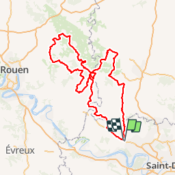
6 km | 7.4 km-effort
1h 45min
Yes
Trail Walking Us - US - La chaussée Brunehaut - Photo
Walking
marcel.F

Walking

Easy
(1)
Us, Ile-de-France, Val-d'Oise, France
11 km | 13 km-effort
2h 50min
Yes
Trail Walking Boissy-l'Aillerie - La chaussée Jules César - Photo
Walking
ppeul

Walking

Very easy
(2)
Boissy-l'Aillerie, Ile-de-France, Val-d'Oise, France
10.9 km | 13.9 km-effort
Unknown
Yes
Trail Walking Vigny - Ligny - Photo
Walking
avdem

Walking

Easy
Vigny, Ile-de-France, Val-d'Oise, France
9.2 km | 11 km-effort
2h 8min
Yes
Trail Walking Puiseux-Pontoise - chaussée Jules cesar - Photo
Walking
unirega

Walking

Medium
Puiseux-Pontoise, Ile-de-France, Val-d'Oise, France
6.8 km | 8.6 km-effort
1h 51min
Yes
Trail Walking Boissy-l'Aillerie - Bois l'Artillerie. Boucle de Courmonbois - Photo
Walking
avdem

Walking

Difficult
(1)
Boissy-l'Aillerie, Ile-de-France, Val-d'Oise, France
11.5 km | 13.3 km-effort
2h 42min
Yes
Trail Walking Boissy-l'Aillerie - Boissy l'Artillerie,, Courcelles sur Viosne - Photo
Walking
avdem

Walking

Medium
Boissy-l'Aillerie, Ile-de-France, Val-d'Oise, France
34 km | 40 km-effort
3h 25min
No
Trail Walking Boissy-l'Aillerie - Boissy l Aillery - Photo
Walking
avdem

Walking

Easy
Boissy-l'Aillerie, Ile-de-France, Val-d'Oise, France
11.4 km | 13.4 km-effort
2h 37min
No
Trail Walking Boissy-l'Aillerie - J Boissy l Ailleie  Courceul sur Viosne - Photo
Walking
avdem

Walking

Very easy
Boissy-l'Aillerie, Ile-de-France, Val-d'Oise, France
11.4 km | 14.3 km-effort
3h 3min
Yes


Close
My subscriptions