


PN DAMPLEUX 15.9 km

GOELERANDO2
User
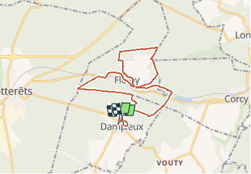

Length
15.9 km

Max alt
200 m

Uphill gradient
311 m
Km-Effort
20 km

Min alt
91 m

Downhill gradient
323 m
Boucle
No
Creation date :
2019-01-15 17:32:05.417
Updated on :
2019-01-15 17:32:05.417
4h19
Difficulty : Difficult

FREE GPS app for hiking
 SityTrail
IGN / Geographical institutes
SityTrail Plus
The world is yours!
About
Trail Walking of 15.9 km to be discovered at Hauts-de-France, Aisne, Dampleux. This trail is proposed by GOELERANDO2.
Description
Départ et parking rue des Cisterciens.
Positioning
Country:
France
Region :
Hauts-de-France
Department/Province :
Aisne
Municipality :
Dampleux
Location:
Unknown
Start:(Dec)
Start:(UTM)
511103 ; 5454590 (31U) N.
Comments