


bec de l'Orien_pas se la clé par col de Montaud

okfred26
User
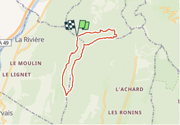

Length
13 km

Max alt
1616 m

Uphill gradient
730 m
Km-Effort
23 km

Min alt
1076 m

Downhill gradient
731 m
Boucle
Yes
Creation date :
2019-01-15 17:40:05.777
Updated on :
2019-01-15 17:40:05.777
5h44
Difficulty : Difficult

FREE GPS app for hiking
 SityTrail
IGN / Geographical institutes
SityTrail Plus
The world is yours!
About
Trail Walking of 13 km to be discovered at Auvergne-Rhône-Alpes, Isère, Montaud. This trail is proposed by okfred26.
Photos


Positioning
Country:
France
Region :
Auvergne-Rhône-Alpes
Department/Province :
Isère
Municipality :
Montaud
Location:
Unknown
Start:(Dec)
Start:(UTM)
699367 ; 5012661 (31T) N.
Comments