![](/images/other/stat-length.png)
![Trail Walking Raimbeaucourt - Autour de Raimbeaucourt par Mons en Pévèle - Photo](https://media.geolcdn.com/t/1900/400/ext.pjpeg?maxdim=2&url=https%3A%2F%2Fservices.sitytrail.com%2FGeolivesWS%2FDownloadMedia.ashx%3FTrailID%3D105798%26Media%3D9706_2.jpg)
Autour de Raimbeaucourt par Mons en Pévèle
tracegps
User
![Length](/images/other/stat-length.png)
Length
14.7 km
![Max alt](https://static1.geolcdn.com/siteimages/upload/files/1508320355ic_sort_altitude_max_24dp.png)
Max alt
94 m
![Uphill gradient](https://static1.geolcdn.com/siteimages/upload/files/1508320355ic_sort_den_pos_24dp.png)
Uphill gradient
134 m
![Km-Effort](/images/other/stat-length.png)
Km-Effort
16.5 km
![Min alt](https://static1.geolcdn.com/siteimages/upload/files/1508320355ic_sort_altitude_min_24dp.png)
Min alt
26 m
![Downhill gradient](https://static1.geolcdn.com/siteimages/upload/files/1508320355ic_sort_den_neg_24dp.png)
Downhill gradient
134 m
![Boucle](https://static1.geolcdn.com/siteimages/upload/files/16400158638029165_repeat_loop_refresh_sync_direction_icon.png)
Boucle
Yes
Creation date :
2014-12-10 00:00:00.0
Updated on :
2014-12-10 00:00:00.0
![Walking](https://static1.geolcdn.com/sitytour/trail-icons/101.png)
3h00
Difficulty : Medium
![Scan this QR Code to open this trail in the SityTrail application](https://capi.geolives.com/qq0zvz2zws4bq2lad0pu/sitytour/trails/105798/qr.png?size=200)
FREE GPS app for hiking
About
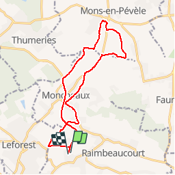
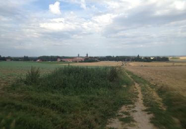
Trail Walking of 14.7 km to be discovered at Hauts-de-France, Nord, Raimbeaucourt. This trail is proposed by tracegps.
Description
Environ 15 km assez Facile. Raimbeaucourt Moncheaux Mons en Mevèle Raimbeaucourt. La 1ère Moitié suivre le GR®121B jusqu’à Mons en Pévèle. À prévoir seconde partie très Boueuse. Plus d'info sur www.nord-gr-randotrek.fr
Positioning
Country:
France
Region :
Hauts-de-France
Department/Province :
Nord
Municipality :
Raimbeaucourt
Location:
Unknown
Start:(Dec)
Start:(UTM)
506054 ; 5587154 (31U) N.
Comments
Trails nearby
![Trail Walking Mons-en-Pévèle - Autour du site ornithologique du bois des Cinq Tailles - Mons en Pévèle - Photo](https://media.geolcdn.com/t/375/260/ext.jpg?maxdim=2&url=https%3A%2F%2Fservices.sitytrail.com%2FGeolivesWS%2FDownloadMedia.ashx%3FTrailID%3D107326%26Media%3D12216_6.jpg)
![Walking Walking](https://static1.geolcdn.com/sitytour/trail-icons/101.png)
Autour du site ornithologique du bois des Cinq Tailles - Mons en Pévèle
Walking
Medium
(4)
Mons-en-Pévèle,
Hauts-de-France,
Nord,
France
![](/images/other/stat-length.png)
11.2 km | 12.8 km-effort
2h 49min
![](https://static1.geolcdn.com/siteimages/upload/files/16400158638029165_repeat_loop_refresh_sync_direction_icon.png)
Yes
![Trail Walking Mons-en-Pévèle - Autour du château d'Assignies à Tourmignies - Mons-en-Pévèle - Photo](https://media.geolcdn.com/t/375/260/ext.jpg?maxdim=2&url=https%3A%2F%2Fservices.sitytrail.com%2FGeolivesWS%2FDownloadMedia.ashx%3FTrailID%3D107253%26Media%3D12133_6.jpg)
![Walking Walking](https://static1.geolcdn.com/sitytour/trail-icons/101.png)
Autour du château d'Assignies à Tourmignies - Mons-en-Pévèle
Walking
Difficult
(2)
Mons-en-Pévèle,
Hauts-de-France,
Nord,
France
![](/images/other/stat-length.png)
12.9 km | 14.3 km-effort
3h 15min
![](https://static1.geolcdn.com/siteimages/upload/files/16400158638029165_repeat_loop_refresh_sync_direction_icon.png)
Yes
![Trail Mountain bike Lallaing - lallaing - la fosse delloye - Photo](https://media.geolcdn.com/t/375/260/ext.jpg?maxdim=2&url=https%3A%2F%2Fservices.sitytrail.com%2FGeolivesWS%2FDownloadMedia.ashx%3FTrailID%3D148722%26Media%3D20120821181041.jpg)
![Mountain bike Mountain bike](https://static1.geolcdn.com/sitytour/trail-icons/202.png)
lallaing - la fosse delloye
Mountain bike
Medium
(1)
Lallaing,
Hauts-de-France,
Nord,
France
![](/images/other/stat-length.png)
26 km | 29 km-effort
1h 41min
![](https://static1.geolcdn.com/siteimages/upload/files/16400158638029165_repeat_loop_refresh_sync_direction_icon.png)
No
![Trail Mountain bike Lallaing - 2012-08-17 lallaing 3 cavaliers - Photo](https://media.geolcdn.com/t/375/260/ext.jpg?maxdim=2&url=https%3A%2F%2Fservices.sitytrail.com%2FGeolivesWS%2FDownloadMedia.ashx%3FTrailID%3D147793%26Media%3D20120817182019.jpg)
![Mountain bike Mountain bike](https://static1.geolcdn.com/sitytour/trail-icons/202.png)
2012-08-17 lallaing 3 cavaliers
Mountain bike
Medium
(1)
Lallaing,
Hauts-de-France,
Nord,
France
![](/images/other/stat-length.png)
44 km | 47 km-effort
2h 50min
![](https://static1.geolcdn.com/siteimages/upload/files/16400158638029165_repeat_loop_refresh_sync_direction_icon.png)
No
![Trail Walking Mons-en-Pévèle - Autour des Voyettes - Mons-en-Pévèle - Photo](https://media.geolcdn.com/t/375/260/ext.jpg?maxdim=2&url=https%3A%2F%2Fservices.sitytrail.com%2FGeolivesWS%2FDownloadMedia.ashx%3FTrailID%3D107254%26Media%3D12134_6.jpg)
![Walking Walking](https://static1.geolcdn.com/sitytour/trail-icons/101.png)
Autour des Voyettes - Mons-en-Pévèle
Walking
Easy
(1)
Mons-en-Pévèle,
Hauts-de-France,
Nord,
France
![](/images/other/stat-length.png)
3 km | 3.6 km-effort
45min
![](https://static1.geolcdn.com/siteimages/upload/files/16400158638029165_repeat_loop_refresh_sync_direction_icon.png)
Yes
![Trail Walking Roost-Warendin - Roost Warendint : Escarpelle et Paturelle - Photo](https://media.geolcdn.com/t/375/260/ext.jpg?maxdim=2&url=https%3A%2F%2Fstatic1.geolcdn.com%2Fsiteimages%2Fupload%2Ffiles%2F1553511878bg_sport_marche.png)
![Walking Walking](https://static1.geolcdn.com/sitytour/trail-icons/101.png)
Roost Warendint : Escarpelle et Paturelle
Walking
Medium
(1)
Roost-Warendin,
Hauts-de-France,
Nord,
France
![](/images/other/stat-length.png)
10.9 km | 12.7 km-effort
2h 47min
![](https://static1.geolcdn.com/siteimages/upload/files/16400158638029165_repeat_loop_refresh_sync_direction_icon.png)
Yes
![Trail Walking Mons-en-Pévèle - le paradis de mons en pévèle - Photo](https://media.geolcdn.com/t/375/260/ext.jpg?maxdim=2&url=https%3A%2F%2Fstatic1.geolcdn.com%2Fsiteimages%2Fupload%2Ffiles%2F1553511878bg_sport_marche.png)
![Walking Walking](https://static1.geolcdn.com/sitytour/trail-icons/101.png)
le paradis de mons en pévèle
Walking
Easy
(1)
Mons-en-Pévèle,
Hauts-de-France,
Nord,
France
![](/images/other/stat-length.png)
8.6 km | 9.8 km-effort
2h 15min
![](https://static1.geolcdn.com/siteimages/upload/files/16400158638029165_repeat_loop_refresh_sync_direction_icon.png)
Yes
![Trail Mountain bike Anhiers - lallaing - Mons en peveles - Photo](https://media.geolcdn.com/t/375/260/ext.jpg?maxdim=2&url=https%3A%2F%2Fstatic1.geolcdn.com%2Fsiteimages%2Fupload%2Ffiles%2F1524743154velo.jpg)
![Mountain bike Mountain bike](https://static1.geolcdn.com/sitytour/trail-icons/202.png)
lallaing - Mons en peveles
Mountain bike
Easy
(1)
Anhiers,
Hauts-de-France,
Nord,
France
![](/images/other/stat-length.png)
27 km | 29 km-effort
1h 32min
![](https://static1.geolcdn.com/siteimages/upload/files/16400158638029165_repeat_loop_refresh_sync_direction_icon.png)
No
![Trail Walking Mons-en-Pévèle - Mons-en-Pévèle - balisage 2024 - Photo](https://media.geolcdn.com/t/375/260/ext.jpg?maxdim=2&url=https%3A%2F%2Fmedia.geolcdn.com%2Ff%2F5a656f5f-9962-482e-97b7-05e2eb1abacc.jpg)
![Walking Walking](https://static1.geolcdn.com/sitytour/trail-icons/101.png)
Mons-en-Pévèle - balisage 2024
Walking
Difficult
Mons-en-Pévèle,
Hauts-de-France,
Nord,
France
![](/images/other/stat-length.png)
11.7 km | 13.2 km-effort
3h 21min
![](https://static1.geolcdn.com/siteimages/upload/files/16400158638029165_repeat_loop_refresh_sync_direction_icon.png)
No