


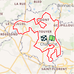
Circuit St Eloi - Chaptelat

tracegps
User

Length
26 km

Max alt
438 m

Uphill gradient
423 m
Km-Effort
31 km

Min alt
325 m

Downhill gradient
423 m
Boucle
Yes
Creation date :
2014-12-10 00:00:00.0
Updated on :
2014-12-10 00:00:00.0
1h45
Difficulty : Medium

FREE GPS app for hiking
 SityTrail
IGN / Geographical institutes
SityTrail Plus
The world is yours!
About
Trail Mountain bike of 26 km to be discovered at New Aquitaine, Haute-Vienne, Chaptelat. This trail is proposed by tracegps.
Description
Circuit très sympathique à faire. 423 m de D . Paysage magnifique en cette entrée de l'automne. Circuit très facile en été. Flaques d'eau et boue en automne sur quelques tronçons.
Photos


Positioning
Country:
France
Region :
New Aquitaine
Department/Province :
Haute-Vienne
Municipality :
Chaptelat
Location:
Unknown
Start:(Dec)
Start:(UTM)
364898 ; 5085408 (31T) N.
Comments
