


HUY ST LEONARD HUY

ochelen
User
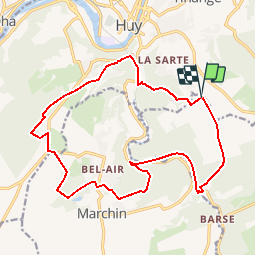

Length
17 km

Max alt
265 m

Uphill gradient
406 m
Km-Effort
22 km

Min alt
83 m

Downhill gradient
407 m
Boucle
Yes
Creation date :
2019-01-15 17:51:34.923
Updated on :
2019-01-15 17:51:34.923
20m
Difficulty : Unknown

FREE GPS app for hiking
 SityTrail
IGN / Geographical institutes
SityTrail Plus
The world is yours!
About
Trail Other activity of 17 km to be discovered at Wallonia, Liège, Huy. This trail is proposed by ochelen.
Positioning
Country:
Belgium
Region :
Wallonia
Department/Province :
Liège
Municipality :
Huy
Location:
Huy
Start:(Dec)
Start:(UTM)
660300 ; 5597322 (31U) N.
Comments