


COL GORODEL PAS DE CLOS PAS DE LA LUERTE

reblan
User
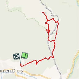

Length
11.3 km

Max alt
1710 m

Uphill gradient
1105 m
Km-Effort
26 km

Min alt
614 m

Downhill gradient
1103 m
Boucle
Yes
Creation date :
2019-01-15 17:52:47.213
Updated on :
2019-01-15 17:52:47.213
9h03
Difficulty : Unknown

FREE GPS app for hiking
 SityTrail
IGN / Geographical institutes
SityTrail Plus
The world is yours!
About
Trail Walking of 11.3 km to be discovered at Auvergne-Rhône-Alpes, Drôme, Châtillon-en-Diois. This trail is proposed by reblan.
Description
2018 10 17
Positioning
Country:
France
Region :
Auvergne-Rhône-Alpes
Department/Province :
Drôme
Municipality :
Châtillon-en-Diois
Location:
Châtillon-en-Diois
Start:(Dec)
Start:(UTM)
697563 ; 4952336 (31T) N.
Comments