


st priest col de l'arégner

guyzinz
User

Length
12.7 km

Max alt
865 m

Uphill gradient
510 m
Km-Effort
19.5 km

Min alt
397 m

Downhill gradient
513 m
Boucle
Yes
Creation date :
2019-06-07 09:38:51.556
Updated on :
2019-06-07 09:38:51.662
4h02
Difficulty : Unknown

FREE GPS app for hiking
 SityTrail
IGN / Geographical institutes
SityTrail Plus
The world is yours!
About
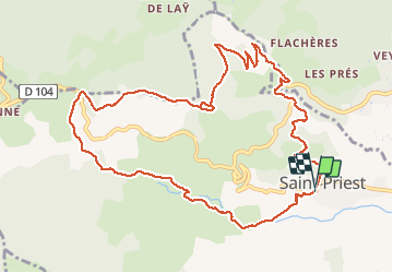
Trail Walking of 12.7 km to be discovered at Auvergne-Rhône-Alpes, Ardèche, Saint-Priest. This trail is proposed by guyzinz.
Description
depart de st priest col de l'arenier montagne de charray
Positioning
Country:
France
Region :
Auvergne-Rhône-Alpes
Department/Province :
Ardèche
Municipality :
Saint-Priest
Location:
Unknown
Start:(Dec)
Start:(UTM)
622411 ; 4952646 (31T) N.
Comments