Trail Walking Cabestany - Chemins autour de Cabestany - Photo

Chemins autour de Cabestany

 tracegps
tracegps

User

© OpenStreetMap contributors
Length
Length
11.8 km
Max alt
Max alt
49 m
Uphill gradient
Uphill gradient
72 m
Km-Effort
Km-Effort  
12.7 km
Min alt
Min alt
5 m
Downhill gradient
Downhill gradient
72 m
Boucle
Boucle
Yes
Creation date :
2014-12-10 00:00:00.0
Updated on :
2014-12-10 00:00:00.0

(2 Reviews)

Walking
Walking
3h00
Difficulty : Medium

Scan this QR Code to open this trail in the SityTrail application

FREE GPS app for hiking

Logo SityTrail SityTrail

IGN / Geographical institutes

Download SityTrail from the App Store Download SityTrail from Google Play

Logo SityTrail SityTrail World

The world is yours!

Download SityTrail from the App Store Download SityTrail from Google Play Download SityTrail on Huawei AppGallery

About

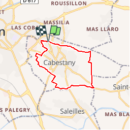
Trail Walking of 11.8 km to be discovered at Occitania, Pyrénées-Orientales, Cabestany. This trail is proposed by tracegps.

Description

La mairie de Cabestany a réhabilité ses chemins de randonnée. Téléchargez la plaquette du circuit,

Elevation profile

Photos

Positioning

Country:
France
Region :
Occitania
Department/Province :
Pyrénées-Orientales
Municipality :
Cabestany
Location:
Unknown
Start:(UTM)
494523 ; 4726398 (31T) N.

Comments

Please log in to post a review or rate the element


Bon parcours très facile. Merci sabrinalx66@gmail.com


Plutôt plat, assez mal indiqué. Idéal pour ce lancer dans la marche.


Trails nearby

Trail Walking Bompas - 66 BOMPAS - promenade en SALANQUE entre Bassas et Agullas - Photo
Walking
jeff66

Walking

Easy
(1)
Bompas, Occitania, Pyrénées-Orientales, France
11.1 km | 11.6 km-effort
2h 36min
Yes
Trail Walking Perpignan - Perpignan 01.10.2017  - Photo
Walking
jeff66

Walking

Easy
(1)
Perpignan, Occitania, Pyrénées-Orientales, France
6.7 km | 7.5 km-effort
1h 39min
No
Trail Walking Saleilles - 66 SALEILLES - St-NAZAIRE, entre FOSSEILLE et REART - Photo
Walking
jeff66

Walking

Easy
(1)
Saleilles, Occitania, Pyrénées-Orientales, France
7.3 km | 7.7 km-effort
1h 8min
Yes
Trail Quad Villeneuve-de-la-Raho -  Villeneuve-de-la-Raho-Collioure (Septembre/Juin) - Photo
Quad
Quad Ride

Quad

Medium
Villeneuve-de-la-Raho, Occitania, Pyrénées-Orientales, France
44 km | 51 km-effort
1h 45min
No
Trail Walking Perpignan - Perpignan  - Photo
Walking
ombrabella

Walking

Very easy
Perpignan, Occitania, Pyrénées-Orientales, France
18 km | 19.9 km-effort
2h 23min
No
Trail Walking Perpignan - 66 PERPIGNAN, quartier MAV au Bas Vernet  - Photo
Walking
jeff66

Walking

Easy
Perpignan, Occitania, Pyrénées-Orientales, France
10.7 km | 11.8 km-effort
1h 45min
Yes
Trail Walking Perpignan - 66 Perpignan Panchot centre bas Vernet centre del mon - Photo
Walking
jeff66

Walking

Easy
Perpignan, Occitania, Pyrénées-Orientales, France
8.6 km | 9.3 km-effort
1h 29min
Yes
Trail Walking Bompas - 66 BOMPAS - itinéraire partagé piétions cycliste en bord de Tet, berge Têt, Bas Vernet, retour par les canaux et centre ville de BOMPAS  - Photo
Walking
jeff66

Walking

Medium
Bompas, Occitania, Pyrénées-Orientales, France
13.4 km | 14.2 km-effort
2h 23min
Yes
Trail Walking Perpignan - 66 PERPIGNAN - mas Balande, parc des sports, aviateurs, St Martin, MAV, Vertefeuille - Photo
Walking
jeff66

Walking

Easy
Perpignan, Occitania, Pyrénées-Orientales, France
10.6 km | 11.6 km-effort
1h 52min
Yes


Close
My subscriptions