


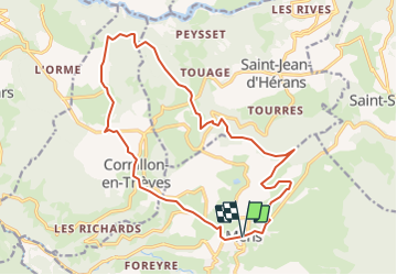
Le Serre Vulson - Mens

tracegps
User


2h40
Difficulty : Very difficult

FREE GPS app for hiking
 SityTrail
IGN / Geographical institutes
SityTrail Plus
The world is yours!
About
Trail Running of 18.7 km to be discovered at Auvergne-Rhône-Alpes, Isère, Mens. This trail is proposed by tracegps.
Description
Circuit n°6 (noir) de la base VTT FFCT du Trièves. Itinéraire pas très difficile techniquement, mais assez long et qui propose une magnifique balade pour découvrir le nord du Canton de Mens, dans une ambiance sportive ... Un régal pour les vététistes confirmés. Au programme, nombreux single tracks, passages techniques et belles descentes.
Positioning
Comments