


GR4 - J11 - La Sagne - Entrevaux

nfranche
User
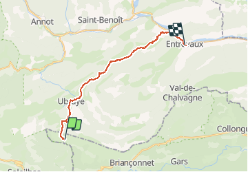

Length
21 km

Max alt
1362 m

Uphill gradient
667 m
Km-Effort
32 km

Min alt
476 m

Downhill gradient
1362 m
Boucle
No
Creation date :
2019-01-15 17:57:49.487
Updated on :
2019-01-15 17:57:49.487
7h38
Difficulty : Difficult

FREE GPS app for hiking
 SityTrail
IGN / Geographical institutes
SityTrail Plus
The world is yours!
About
Trail Walking of 21 km to be discovered at Provence-Alpes-Côte d'Azur, Maritime Alps, Briançonnet. This trail is proposed by nfranche.
Positioning
Country:
France
Region :
Provence-Alpes-Côte d'Azur
Department/Province :
Maritime Alps
Municipality :
Briançonnet
Location:
Unknown
Start:(Dec)
Start:(UTM)
314455 ; 4861222 (32T) N.
Comments