


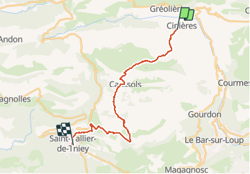
GR4-J15 - Gréolière - St-vallée de Thiey

nfranche
User

Length
23 km

Max alt
1284 m

Uphill gradient
774 m
Km-Effort
34 km

Min alt
715 m

Downhill gradient
873 m
Boucle
No
Creation date :
2019-01-15 17:57:50.319
Updated on :
2019-01-15 17:57:50.319
8h41
Difficulty : Medium

FREE GPS app for hiking
 SityTrail
IGN / Geographical institutes
SityTrail Plus
The world is yours!
About
Trail Walking of 23 km to be discovered at Provence-Alpes-Côte d'Azur, Maritime Alps, Cipières. This trail is proposed by nfranche.
Positioning
Country:
France
Region :
Provence-Alpes-Côte d'Azur
Department/Province :
Maritime Alps
Municipality :
Cipières
Location:
Unknown
Start:(Dec)
Start:(UTM)
335168 ; 4849542 (32T) N.
Comments