


Boucle Duranus Col Saint Roch

sylvainstaels
User
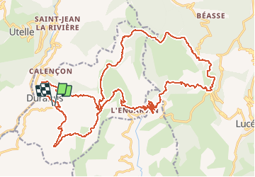

Length
33 km

Max alt
1272 m

Uphill gradient
1560 m
Km-Effort
53 km

Min alt
379 m

Downhill gradient
1564 m
Boucle
Yes
Creation date :
2019-01-15 17:58:11.789
Updated on :
2019-01-15 17:58:11.789
3h20
Difficulty : Difficult

FREE GPS app for hiking
 SityTrail
IGN / Geographical institutes
SityTrail Plus
The world is yours!
About
Trail Mountain bike of 33 km to be discovered at Provence-Alpes-Côte d'Azur, Maritime Alps, Duranus. This trail is proposed by sylvainstaels.
Positioning
Country:
France
Region :
Provence-Alpes-Côte d'Azur
Department/Province :
Maritime Alps
Municipality :
Duranus
Location:
Unknown
Start:(Dec)
Start:(UTM)
360548 ; 4861216 (32T) N.
Comments