


la Gleize-coo

albert318
User
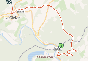

Length
7.5 km

Max alt
504 m

Uphill gradient
361 m
Km-Effort
12 km

Min alt
235 m

Downhill gradient
271 m
Boucle
No
Creation date :
2019-01-15 18:05:31.02
Updated on :
2020-02-27 00:13:56.553
2h33
Difficulty : Easy

FREE GPS app for hiking
 SityTrail
IGN / Geographical institutes
SityTrail Plus
The world is yours!
About
Trail Walking of 7.5 km to be discovered at Wallonia, Liège, Stavelot. This trail is proposed by albert318.
Description
Trajet par les aires d'envol des parapentes
Positioning
Country:
Belgium
Region :
Wallonia
Department/Province :
Liège
Municipality :
Stavelot
Location:
Stavelot
Start:(Dec)
Start:(UTM)
704601 ; 5586644 (31U) N.
Comments