Trail Mountain bike Tourtouse - Espace VTT FFC Couserans-Volvestre en Pyrénées - Sentier de Naudot et Guillou n°06 - Photo

Espace VTT FFC Couserans-Volvestre en Pyrénées - Sentier de Naudot et Guillou n°06

 tracegps
tracegps

User

© OpenStreetMap contributors
Length
Length
17 km
Max alt
Max alt
565 m
Uphill gradient
Uphill gradient
342 m
Km-Effort
Km-Effort  
22 km
Min alt
Min alt
362 m
Downhill gradient
Downhill gradient
343 m
Boucle
Boucle
Yes
Creation date :
2014-12-10 00:00:00.0
Updated on :
2014-12-10 00:00:00.0

(1 Reviews)

Mountain bike
Mountain bike
1h19
Difficulty : Medium

Scan this QR Code to open this trail in the SityTrail application

FREE GPS app for hiking

Logo SityTrail SityTrail

IGN / Geographical institutes

Download SityTrail from the App Store Download SityTrail from Google Play

Logo SityTrail SityTrail World

The world is yours!

Download SityTrail from the App Store Download SityTrail from Google Play Download SityTrail on Huawei AppGallery

About

Trail Mountain bike of 17 km to be discovered at Occitania, Ariège, Tourtouse. This trail is proposed by tracegps.

Description

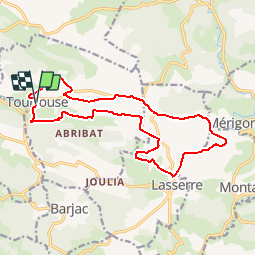
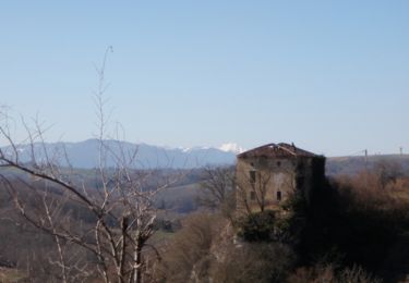
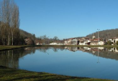
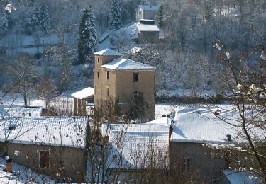
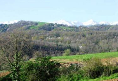
Espace VTT FFC Couserans-Volvestre en Pyrénées - Sentier de Naudot et Guillou n°06. Circuit officiel labellisé par la Fédération Française de Cyclisme. Entre la fraîcheur du milieu forestier, la chaleur des coteaux secs et ensoleillés de la quère d’Arbas et les panoramas exceptionnels sur la chaîne pyrénéenne (Lasserre: belvédère sur les Pyrénées), cet itinéraire relativement facile vous offre un cheminement riche et varié pour découvrir un beau petit coin du Volvestre. Ce circuit peut se faire en deux fois. Renseignements ; • Office de Tourisme Volvestre Couserans Place de l’Espy 09230 SAINTE-CROIX VOLVESTRE - Tél. 05 61 04 60 55 // Fax 05 61 66 27 98 - ot.volvestre.ariegeois (at) wanadoo.fr • Office de Tourisme de Saint-Lizier - Place Notre dame 09190 SAINT-LIZIER - Tél. 05 61 96 77 77 - ot.saintlizier (at) wanadoo.fr

Elevation profile

Photos

Positioning

Country:
France
Region :
Occitania
Department/Province :
Ariège
Municipality :
Tourtouse
Location:
Unknown
Start:(UTM)
347354 ; 4772773 (31T) N.

Comments

Please log in to post a review or rate the element


Trails nearby

Trail Mountain bike Tourtouse - Volvestre Tout Terrain  - Photo
Mountain bike
tracegps

Mountain bike

Difficult
(2)
Tourtouse, Occitania, Ariège, France
30 km | 43 km-effort
3h 0min
Yes
Trail Mountain bike Sainte-Croix-Volvestre - Espace VTT FFC Couserans-Volvestre en Pyrénées - Sentier de Paouêt n°01 - Photo
Mountain bike
tracegps

Mountain bike

Medium
(2)
Sainte-Croix-Volvestre, Occitania, Ariège, France
5.1 km | 7 km-effort
30min
Yes
Trail Walking Sainte-Croix-Volvestre - Sainte Croix Volvestre, boucle de 13km - Photo
Walking
eric09

Walking

Medium
Sainte-Croix-Volvestre, Occitania, Ariège, France
13.3 km | 18.2 km-effort
3h 51min
Yes
Trail Mountain bike Bagert - Espace VTT FFC Couserans-Volvestre en Pyrénées - Sentier de Bergès n°10 - Photo
Mountain bike
tracegps

Mountain bike

Difficult
Bagert, Occitania, Ariège, France
6.5 km | 10 km-effort
40min
Yes
Trail Mountain bike Sainte-Croix-Volvestre - Espace VTT FFC Couserans-Volvestre en Pyrénées - Sentier de Maharage n°02  - Photo
Mountain bike
tracegps

Mountain bike

Medium
(1)
Sainte-Croix-Volvestre, Occitania, Ariège, France
13.3 km | 16.7 km-effort
1h 10min
Yes
Trail Mountain bike Sainte-Croix-Volvestre - Les pré Pyrénées à Ste Croix Volvestre - Photo
Mountain bike
tracegps

Mountain bike

Medium
Sainte-Croix-Volvestre, Occitania, Ariège, France
21 km | 28 km-effort
2h 0min
Yes
Trail Walking Sainte-Croix-Volvestre - Les pré Pyrénées à Ste Croix Volvestre - Photo
Walking
tracegps

Walking

Difficult
(1)
Sainte-Croix-Volvestre, Occitania, Ariège, France
21 km | 28 km-effort
4h 0min
Yes
Trail On foot Sainte-Croix-Volvestre - Sentier de Peyre - Photo
On foot
PRO

On foot

Easy
Sainte-Croix-Volvestre, Occitania, Ariège, France
4.9 km | 7.2 km-effort
1h 37min
No
Trail Walking Sainte-Croix-Volvestre - Sainte croix volvestre  - Photo
Walking
Fafou64

Walking

Easy
Sainte-Croix-Volvestre, Occitania, Ariège, France
50 km | 68 km-effort
2h 20min
No


Close
My subscriptions