Trail Running Montjoire - De Montjoire aux Toulzas par Lacour - Photo

De Montjoire aux Toulzas par Lacour

 tracegps
tracegps

User

© OpenStreetMap contributors
Length
Length
11.6 km
Max alt
Max alt
241 m
Uphill gradient
Uphill gradient
209 m
Km-Effort
Km-Effort  
14.4 km
Min alt
Min alt
128 m
Downhill gradient
Downhill gradient
206 m
Boucle
Boucle
Yes
Creation date :
2014-12-10 00:00:00.0
Updated on :
2014-12-10 00:00:00.0

(0 Reviews)

Running
Running
1h15
Difficulty : Medium

Scan this QR Code to open this trail in the SityTrail application

FREE GPS app for hiking

Logo SityTrail SityTrail

IGN / Geographical institutes

Download SityTrail from the App Store Download SityTrail from Google Play

Logo SityTrail SityTrail World

The world is yours!

Download SityTrail from the App Store Download SityTrail from Google Play Download SityTrail on Huawei AppGallery

About

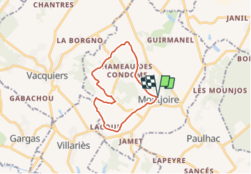
Trail Running of 11.6 km to be discovered at Occitania, Haute-Garonne, Montjoire. This trail is proposed by tracegps.

Description

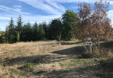
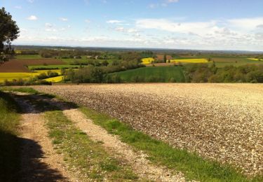
Départ de la table d’orientation de Montjoire, un très beau village perché. Une succession de chemins, de parties goudronnées pour une boucle très agréable puisque l’essentiel du dénivelé positif est concentré sur les 2 derniers km !! De vastes paysages lors des nombreux passages en crêtes.

Elevation profile

Photos

Positioning

Country:
France
Region :
Occitania
Department/Province :
Haute-Garonne
Municipality :
Montjoire
Location:
Unknown
Start:(UTM)
381969 ; 4847428 (31T) N.

Trails nearby

Trail Walking Villariès - De Villariès à Vacquiers - Photo
Walking
tracegps

Walking

Medium
(1)
Villariès, Occitania, Haute-Garonne, France
11.5 km | 13.4 km-effort
3h 0min
Yes
Trail Walking Montjoire - De Montjoire aux Toulzas par Lacour - Photo
Walking
tracegps

Walking

Medium
(2)
Montjoire, Occitania, Haute-Garonne, France
11.6 km | 14.4 km-effort
3h 0min
Yes
Trail On foot Montjoire - Balade panoramique autour de Montjoire - Photo
On foot
PRO

On foot

Easy
(1)
Montjoire, Occitania, Haute-Garonne, France
11.7 km | 14.5 km-effort
3h 17min
Yes
Trail Walking Buzet-sur-Tarn - Randonnée de Kissifrotte - Photo
Walking
Mipe

Walking

Very easy
Buzet-sur-Tarn, Occitania, Haute-Garonne, France
3.8 km | 4.4 km-effort
1h 13min
Yes
Trail Running Villariès - De Villariès à Vacquiers - Photo
Running
tracegps

Running

Medium
Villariès, Occitania, Haute-Garonne, France
11.5 km | 13.4 km-effort
1h 15min
Yes
Trail Mountain bike Montjoire - De Montjoire aux Toulzas par Lacour - Photo
Mountain bike
tracegps

Mountain bike

Medium
Montjoire, Occitania, Haute-Garonne, France
11.6 km | 14.4 km-effort
49min
Yes
Trail Running Vacquiers - De Vacquiers à la Verrière - Photo
Running
tracegps

Running

Easy
Vacquiers, Occitania, Haute-Garonne, France
10.8 km | 13 km-effort
1h 0min
Yes
Trail Walking Buzet-sur-Tarn - Buzet - Photo
Walking
jlmauriz

Walking

Medium
Buzet-sur-Tarn, Occitania, Haute-Garonne, France
6.9 km | 7.7 km-effort
1h 58min
Yes
Trail Running Vacquiers - De Vacquiers à la Forêt Royale - Photo
Running
tracegps

Running

Medium
Vacquiers, Occitania, Haute-Garonne, France
10.8 km | 12.9 km-effort
1h 10min
Yes


Close
My subscriptions