Trail Walking Bonningues-lès-Ardres - Botte de Tournehem - Quercamps - Photo
 tracegps
tracegps

User

© OpenStreetMap contributors
Length
Length
5.4 km
Max alt
Max alt
197 m
Uphill gradient
Uphill gradient
107 m
Km-Effort
Km-Effort  
6.9 km
Min alt
Min alt
97 m
Downhill gradient
Downhill gradient
106 m
Boucle
Boucle
Yes
Creation date :
2014-12-10 00:00:00.0
Updated on :
2014-12-10 00:00:00.0

(1 Reviews)

Walking
Walking
1h10
Difficulty : Easy

Scan this QR Code to open this trail in the SityTrail application

FREE GPS app for hiking

Logo SityTrail SityTrail

IGN / Geographical institutes

Download SityTrail from the App Store Download SityTrail from Google Play

Logo SityTrail SityTrail World

The world is yours!

Download SityTrail from the App Store Download SityTrail from Google Play Download SityTrail on Huawei AppGallery

About

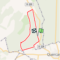
Trail Walking of 5.4 km to be discovered at Hauts-de-France, Pas-de-Calais, Bonningues-lès-Ardres. This trail is proposed by tracegps.

Description

De Quercamps, prendre la direction Tournehem. Au premier croisement de route forestière, prendre à gauche et stationner. Le départ commence juste après la barrière. Le circuit décrit une forme de botte, entièrement en sous bois et emprunte partiellement le sentier équestre "Noire Vallée". Par temps humide, prévoir de bonnes chaussures.

Elevation profile

Photos

Positioning

Country:
France
Region :
Hauts-de-France
Department/Province :
Pas-de-Calais
Municipality :
Bonningues-lès-Ardres
Location:
Unknown
Start:(UTM)
432095 ; 5623765 (31U) N.

Comments

Please log in to post a review or rate the element


Trails nearby

Trail Walking Tournehem-sur-la-Hem - La chapelle Saint-Louis - Tournehem sur la Hem - Photo
Walking
tracegps

Walking

Medium
(4)
Tournehem-sur-la-Hem, Hauts-de-France, Pas-de-Calais, France
9.1 km | 11.2 km-effort
2h 30min
Yes
Trail Mountain bike Quercamps - Le Héricat - Quercamps - Photo
Mountain bike
tracegps

Mountain bike

Medium
Quercamps, Hauts-de-France, Pas-de-Calais, France
23 km | 28 km-effort
2h 30min
Yes
Trail Walking Audrehem - La Ligne d'Anvin - Audrehem - Photo
Walking
tracegps

Walking

Medium
Audrehem, Hauts-de-France, Pas-de-Calais, France
8.6 km | 9.6 km-effort
2h 0min
Yes
Trail Walking Bouvelinghem - Les quatre bois - Photo
Walking
Lecoester

Walking

Medium
Bouvelinghem, Hauts-de-France, Pas-de-Calais, France
11.6 km | 14.7 km-effort
3h 5min
Yes
Trail Walking Alquines - Le Mont Vert - Alquines - Photo
Walking
tracegps

Walking

Difficult
Alquines, Hauts-de-France, Pas-de-Calais, France
12.6 km | 15.8 km-effort
3h 10min
Yes
Trail Mountain bike Acquin-Westbécourt - 2011-10-16 - 11h33m49 - Photo
Mountain bike
samuel62380

Mountain bike

Very easy
Acquin-Westbécourt, Hauts-de-France, Pas-de-Calais, France
22 km | 26 km-effort
2h 15min
Yes
Trail Walking Tournehem-sur-la-Hem - Belvédère sur la mer - Photo
Walking
neitag61

Walking

Easy
Tournehem-sur-la-Hem, Hauts-de-France, Pas-de-Calais, France
9.2 km | 11.3 km-effort
2h 30min
Yes
Trail Walking Acquin-Westbécourt - val d'Avquin - Photo
Walking
Geliot

Walking

Medium
Acquin-Westbécourt, Hauts-de-France, Pas-de-Calais, France
9.5 km | 11.6 km-effort
2h 27min
Yes
Trail Walking Acquin-Westbécourt - Acquin - Le Noovre - Photo
Walking
jlmerlevede

Walking

Very easy
Acquin-Westbécourt, Hauts-de-France, Pas-de-Calais, France
9.5 km | 11.5 km-effort
2h 30min
Yes


Close
My subscriptions